
-

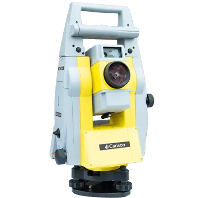
 End of year special: CRx 2" with RT5 Tablet plus SurvPC Total Station & RTS The Carlson CRx series of Robotic Total Stations provides a choice of 1″, 2″ and 5″ angular resolutions to match the application requirements. This offer is for the 2". This model is the CRx-5 for a seamless user experience. The instruments are combined with SurvCE or SurvPC on a field computer to access the full range of Carlson survey features for efficiency and automation in a familiar environment. In addition, users have the option for installing SurvCE Basic on board for operation with the instrument only. Customers benefit from technical guidance and support for both the robotic total station and SurvCE or SurvPC from one company. CRx Robotic Total Stations are used with SurvCE or SurvPC in a wide range of applications requiring precise angle and distance measurements such as surveying, engineering and construction.
 -
End of year special: CRx 5" plus RT5 Tablet w/ SurvPC Total Station & RTS The Carlson CRx series of Robotic Total Stations provides a choice of 1″, 2″ and 5″ angular resolutions to match the application requirements. This offer is for the 5". This model is the CRx-5 for a seamless user experience. The instruments are combined with SurvCE or SurvPC on a field computer to access the full range of Carlson survey features for efficiency and automation in a familiar environment. In addition, users have the option for installing SurvCE Basic on board for operation with the instrument only. Customers benefit from technical guidance and support for both the robotic total station and SurvCE or SurvPC from one company. CRx Robotic Total Stations are used with SurvCE or SurvPC in a wide range of applications requiring precise angle and distance measurements such as surveying, engineering and construction.
-
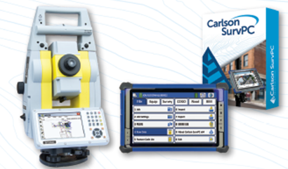
 SurvPC supports the widest range of popular and newly released RTK GPS and conventional and robotic total stations, putting the power of Carlson’s in-field coordinate geometry at your fingertips. Note that this is an upgrade from Version 6 - click here to buy SurvPC 7 instead of an upgrade. You can add own the Carlson SurvPC Robotic Module here: New features of SurvPC 7 include:
- SurvNet least squares adjustment in the field
- BIM Support for viewing and 2D/3D staking (IFC and RVT)
- Esri ArcGIS Online integration
- Enhanced graphical averaging with full data visibility
- Customizable report generation with field email option
- Catenary survey for robotic total station
- Auto refreshing reference drawings
- Total station monitoring
- Advances in road staking to support BIM and DTM models with real time sectioning
- Fully customizable user hot list
-
There’s a reason surveyors make Carlson their first choice in data collection software. SurvPC combines advanced functionality, ease-of-use, and cutting-edge features with excellent service and award-winning technical support. SurvPC supports the widest range of popular and newly released RTK GPS and conventional and robotic total stations, putting the power of Carlson’s in-field coordinate geometry at your fingertips. New features of SurvPC 7 include:
- SurvNet least squares adjustment in the field
- BIM Support for viewing and 2D/3D staking (IFC and RVT)
- Esri ArcGIS Online integration
- Enhanced graphical averaging with full data visibility
- Customizable report generation with field email option
- Catenary survey for robotic total station
- Auto refreshing reference drawings
- Total station monitoring
- Advances in road staking to support BIM and DTM models with real time sectioning
- Fully customizable user hot list
-
SurvPC supports the widest range of popular and newly released RTK GPS and conventional and robotic total stations, putting the power of Carlson’s in-field coordinate geometry at your fingertips. Note that this requires SurvPC Basic (TS). New features of SurvPC 7 include:
- SurvNet least squares adjustment in the field
- BIM Support for viewing and 2D/3D staking (IFC and RVT)
- Esri ArcGIS Online integration
- Enhanced graphical averaging with full data visibility
- Customizable report generation with field email option
- Catenary survey for robotic total station
- Auto refreshing reference drawings
- Total station monitoring
- Advances in road staking to support BIM and DTM models with real time sectioning
- Fully customizable user hot list
Who We Are
Allenbuild Instruments LLC
Address: Turning Point Drive, Wake Forest, NC 27587, USA
Tel: +1 (919) 761-5140
Email: Click here to email us
Quick Links
© Copyright 2024 | Allenbuild Instruments | All Rights Reserved | Designed by Sally Compton