


Product description
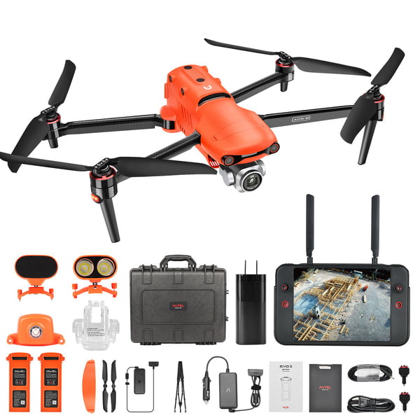
EVO II Pro RTK packages from Carlson include:
• Aircraft with RTK module
• 3 Flight batteries
• Smart Controller with mission planning software
• 10 ground targets
• Chargers and cables
• 32gb SD card
• Controller neck strap
• Rugged hard case
• Spare propeller pair
Autel EVO II Pro RTK AIRCRAFT SPECIFICATIONS
| Weight (with propeller and battery) | 1237g±0.5g |
| Wheelbase | 397 mm |
| Maximum Service Ceiling Altitude | 6000 m |
| Max ascent speed | 5 m/s(automatic flight) 8 m/s(manual control) |
| Max descent speed | 4 m/s |
| Max horizontal flight speed | 72 km/h |
| Max tilt angle | 33° |
| Max angular velocity | 120°/s |
| Max flight time | 36 min |
| Operating temperature range | -10℃ ~ 40℃ |
| Maximum resistance to wind | Level 8 (39-46mph/62-74kph) |
| Operating frequency | non-Japan:2.400 GHz – 2.4835 GHz;5.725 – 5.850 GHz Japan:2.400 GHz – 2.4835 GHz;5.650 – 5.755 GHz |
| Transmission power | 2.4GHz FCC/ISED:≤27dBm SRRC/CE/MIC/RCM:≤20dBm 5.8G (non-Japan) ; 5.7G (non-Japan) FCC/ISED/SRRC/MIC:≤27dBm CE/ RCM:≤14dBm |
| Hovering accuracy |
When RTK is enabled and working normally:
Vertical: ±0.1 m; Horizontal: ±0.1 m RTK is not enabled: vertical: ±0.1 m (when the visual positioning is working normally); ±0.5 m (when GNSS positioning works normally) Level: ±0.3 m (when the visual positioning is working normally); ±1.5 m (when GNSS positioning works normally) |
| Image position compensation |
The position of the camera center relative to the phase center of the airborne A-RTK antenna, under the body axis system: (-2.63, 0.31, 83.5) mm, and the photo EXIF coordinates have been compensated. The positive XYZ axis of the body axis system points to the front, right, and bottom of the aircraft respectively.
|
| Note: Operating frequency varies by countries and regions, please refer to local laws and regulations. |
GNSS AND GIMBAL SPECIFICATIONS
| Single frequency high sensitivity GNSS | GPS+BeiDou+Galileo(Asia) GPS+GLONASS+Galileo(Other areas) |
| Multi-frequency multi-system high-precision RTK GNSS | Frequency points used: GPS:L1/L2; GLONASS:L1/L2; BeiDou:B1/B2; Galileo:E1/E5 First positioning time:<50 s Positioning accuracy: Vertical 1.5 cm + 1 ppm (RMS); Horizontal 1 cm + 1 ppm (RMS) 1 ppm means that the error increases by 1 mm for every 1 km the aircraft moves |
| Gimbal | Three-axis stabilization |
| Mechanical range | Tilt:-135° to +45° Pan:-100° to +100° |
| Controllable rotation range | Tilt:-90° to +30° Pan:-90° to +90° |
| Max control speed (Tilt) | 300°/s |
| Angular Vibration Range | ±0.005° |
REMOTE CONTROLLER AND IMAGE TRANSMISSION SPECIFICATIONS
| Transmission power | 2.4~2.4835GHz FCC/ISED:≤27dBm SRRC/CE/MIC/RCM:≤20dBm 5.725~5.850GHz FCC/ISED/SRRC/MIC:≤27dBm CE/RCM:≤14dBm |
| Max Transmission Distance (unobstructed, free of interference) | FCC:9 km CE:5 km |
| Real-time image transmission quality | 720p@30fps / 1080p@30fps |
| Maximum bit rate of real-time image transmission | 40Mbps |
| Display screen | 7.9” OLED 854(W) * 480(H)Pixel Directly preview the video without connecting a mobile phone |
| Remote controller battery | 5000mAh |
| Run time | 3 hours |
| Charging time | 2 hours fast charging |
| Working current/voltage | 1.7A@3.7V |
| Note: Operating frequency varies by countries and regions, please refer to local laws and regulations. |
SENSING SYSTEM SPECIFICATIONS
| Sensing system type | Omnidirectional sensing system |
| Forward | Accurate measurement range: 0.5-20 m Detection range: 0.5-40 m Effective sensing speed:<15m/s Viewing angle: Horizontal: 60°, Vertical: 80° |
| Backward | Accurate measuring range: 0.5-16 m Detection range: 0.5-32 m Effective sensing speed:<12m/s Viewing angle: Horizontal: 60°, Vertical: 80° |
| Upward | Accurate measurement range: 0.5-12 m Detection range: 0.5-24 m Effective sensing speed:<6m/s Viewing angle: horizontal: 65°, vertical: 50° |
| Downward | Accurate measurement range: 0.5-11 m Detection range: 0.5-22 m Effective sensing speed:<6m/s Viewing angle: horizontal: 100°, vertical: 80° |
| Left and right | Accurate measurement range: 0.5-12 m Detection range: 0.5-24 m Effective sensing speed:<10m/s Viewing angle: horizontal: 65°, vertical: 50° |
| Operating Environment | 15)nUpward:nDetects diffuse reflective surfaces (>20%)n(walls, trees, people, etc.)nDownward:nSurface with clear pattern and adequate lighting (lux > 15)nDetects diffuse reflective surfaces (>20%)n(walls, trees, people, etc.)”}”>Forward, Backward and Sides: Surface with clear pattern and adequate lighting (lux > 15) Upward: Detects diffuse reflective surfaces (>20%) (walls, trees, people, etc.) Downward: Surface with clear pattern and adequate lighting (lux > 15) Detects diffuse reflective surfaces (>20%) (walls, trees, people, etc.) |
CAMERA SPECIFICATIONS
| Sensor | 1 inch CMOS; 20 million effective pixels |
| Lens | FOV 82° Aperture f/2.8 – f/11 Focus range: 1m to infinity (with auto focus) |
| ISO range | Video:100 – 6400 Photos:100 – 12800 |
| Electronic shutter | 8 – 1/8000 s |
| Zoom | 1 – 16 times |
| Photo mode | Single shot Burst shooting: 3/5 frames Auto Exposure Bracketing (AEB): 3/5 bracketed frames at 0.7 EV Bias Time Lapse: JPG:2s/5s/7s/10s/20s/30s/60s DNG:5s/7s/10s/20s/30s/60s HyperLight: support (under 4K JPEG format) Long exposure:Max. 8s HDR imaging: support (under 4K JPEG format) |
| Photo resolution | 5472*3648 (3:2) 5472*3076 (16:9) 3840*2160 (16:9) |
| Video resolution | 6K 5472*3076 p30/p25/p24 4K 3840*2160 p60/p50/p48/p30/p25/p24 2.7K 2720*1528 p120/p60/p50/p48/p30/p25/p24 1080P 1920*1080 p120/p60/p50/p48/p30/p25/p24 |
| Effective frame | 5472×3648 |
| Max bitrate | 120 Mbps |
| Photo format | JPG(default);DNG |
| Video format | MOV(default);MP4 |
| Supported file system | 32 GB)”}”>FAT32(≤ 32 GB); exFAT(> 32 GB) |
| Supported SD cards | Class4 / Class10 / U3 Capacity:4G / 8G / 16G / 32G / 128G |
BATTERY AND CHARGER SPECIFICATIONS
| Battery: | |
| Capacity | 7100 mAh, 82 Wh |
| Voltage | 11.55 V |
| Battery type | LiPo 3S |
| Weight | 365 g |
| Charging temperature range | 5℃ to 45℃ |
| Storage temperature and humidity | -10~30℃,65±20%RH |
| Max charging power | 93W |
| Charging time | 90 minutes |
| Charger: | |
| Input | 100-240 V, 50/60 Hz, 1.5A |
| Output | 13.2 V ⎓ 5 A 5V⎓3A 9V⎓2A 12V⎓1.5A |
| Voltage | 13.2±0.1V |
| Rated power | 66W |
STORAGE SPECIFICATIONS
| Internal storage | 8GB |
| SD storage | Standard: 32 GB, max. support 256GB (UHS-3 rating required) |
CREATE POINT CLOUDS, ORTHOIMAGES, TINS, LINEWORK, AND MORE WITH CARLSON PHOTOCAPTURE

With Carlson PhotoCapture drone photo processing software, you can use the date collected with your EVO II Pro RTK to:
• Quickly generate interactive 3D maps of sites
• Capture highly accurate 3D site data from any camera
• Share site maps with customers – anywhere, anytime!
• Save man-hours in the field
PhotoCapture is available both as a cloud-based service at photocapture.carlsonsw.comand as an unlimited, standalone desktop application. Learn More >>
LISTEN & BRX7 FOR RTK ANYWHERE
Carlson Listen-Listen is a cloud-based service that sends corrections over the cellular data network from a base BRx7 to a rover or RTK drone. Available to Carlson SurvCE and SurvPC customers using Carlson’s BRx7 GNSS receiver as a base station, the system eliminates the need for network corrections, is available with NTRIP for RTK drone support, and is hosted through Amazon Web Services for unlimited processing power, speed, and bandwidth.
Autel EVO II Pro RTK AIRCRAFT SPECIFICATIONS
| Weight (with propeller and battery) | 1237g±0.5g |
| Wheelbase | 397 mm |
| Maximum Service Ceiling Altitude | 6000 m |
| Max ascent speed | 5 m/s(automatic flight) 8 m/s(manual control) |
| Max descent speed | 4 m/s |
| Max horizontal flight speed | 72 km/h |
| Max tilt angle | 33° |
| Max angular velocity | 120°/s |
| Max flight time | 36 min |
| Operating temperature range | -10℃ ~ 40℃ |
| Maximum resistance to wind | Level 8 (39-46mph/62-74kph) |
| Operating frequency | non-Japan:2.400 GHz – 2.4835 GHz;5.725 – 5.850 GHz Japan:2.400 GHz – 2.4835 GHz;5.650 – 5.755 GHz |
| Transmission power | 2.4GHz FCC/ISED:≤27dBm SRRC/CE/MIC/RCM:≤20dBm 5.8G (non-Japan) ; 5.7G (non-Japan) FCC/ISED/SRRC/MIC:≤27dBm CE/ RCM:≤14dBm |
| Hovering accuracy |
When RTK is enabled and working normally:
Vertical: ±0.1 m; Horizontal: ±0.1 m RTK is not enabled: vertical: ±0.1 m (when the visual positioning is working normally); ±0.5 m (when GNSS positioning works normally) Level: ±0.3 m (when the visual positioning is working normally); ±1.5 m (when GNSS positioning works normally) |
| Image position compensation |
The position of the camera center relative to the phase center of the airborne A-RTK antenna, under the body axis system: (-2.63, 0.31, 83.5) mm, and the photo EXIF coordinates have been compensated. The positive XYZ axis of the body axis system points to the front, right, and bottom of the aircraft respectively.
|
| Note: Operating frequency varies by countries and regions, please refer to local laws and regulations. |
GNSS AND GIMBAL SPECIFICATIONS
| Single frequency high sensitivity GNSS | GPS+BeiDou+Galileo(Asia) GPS+GLONASS+Galileo(Other areas) |
| Multi-frequency multi-system high-precision RTK GNSS | Frequency points used: GPS:L1/L2; GLONASS:L1/L2; BeiDou:B1/B2; Galileo:E1/E5 First positioning time:<50 s Positioning accuracy: Vertical 1.5 cm + 1 ppm (RMS); Horizontal 1 cm + 1 ppm (RMS) 1 ppm means that the error increases by 1 mm for every 1 km the aircraft moves |
| Gimbal | Three-axis stabilization |
| Mechanical range | Tilt:-135° to +45° Pan:-100° to +100° |
| Controllable rotation range | Tilt:-90° to +30° Pan:-90° to +90° |
| Max control speed (Tilt) | 300°/s |
| Angular Vibration Range | ±0.005° |
REMOTE CONTROLLER AND IMAGE TRANSMISSION SPECIFICATIONS
| Transmission power | 2.4~2.4835GHz FCC/ISED:≤27dBm SRRC/CE/MIC/RCM:≤20dBm 5.725~5.850GHz FCC/ISED/SRRC/MIC:≤27dBm CE/RCM:≤14dBm |
| Max Transmission Distance (unobstructed, free of interference) | FCC:9 km CE:5 km |
| Real-time image transmission quality | 720p@30fps / 1080p@30fps |
| Maximum bit rate of real-time image transmission | 40Mbps |
| Display screen | 7.9” OLED 854(W) * 480(H)Pixel Directly preview the video without connecting a mobile phone |
| Remote controller battery | 5000mAh |
| Run time | 3 hours |
| Charging time | 2 hours fast charging |
| Working current/voltage | 1.7A@3.7V |
| Note: Operating frequency varies by countries and regions, please refer to local laws and regulations. |
SENSING SYSTEM SPECIFICATIONS
| Sensing system type | Omnidirectional sensing system |
| Forward | Accurate measurement range: 0.5-20 m Detection range: 0.5-40 m Effective sensing speed:<15m/s Viewing angle: Horizontal: 60°, Vertical: 80° |
| Backward | Accurate measuring range: 0.5-16 m Detection range: 0.5-32 m Effective sensing speed:<12m/s Viewing angle: Horizontal: 60°, Vertical: 80° |
| Upward | Accurate measurement range: 0.5-12 m Detection range: 0.5-24 m Effective sensing speed:<6m/s Viewing angle: horizontal: 65°, vertical: 50° |
| Downward | Accurate measurement range: 0.5-11 m Detection range: 0.5-22 m Effective sensing speed:<6m/s Viewing angle: horizontal: 100°, vertical: 80° |
| Left and right | Accurate measurement range: 0.5-12 m Detection range: 0.5-24 m Effective sensing speed:<10m/s Viewing angle: horizontal: 65°, vertical: 50° |
| Operating Environment | 15)nUpward:nDetects diffuse reflective surfaces (>20%)n(walls, trees, people, etc.)nDownward:nSurface with clear pattern and adequate lighting (lux > 15)nDetects diffuse reflective surfaces (>20%)n(walls, trees, people, etc.)”}”>Forward, Backward and Sides: Surface with clear pattern and adequate lighting (lux > 15) Upward: Detects diffuse reflective surfaces (>20%) (walls, trees, people, etc.) Downward: Surface with clear pattern and adequate lighting (lux > 15) Detects diffuse reflective surfaces (>20%) (walls, trees, people, etc.) |
CAMERA SPECIFICATIONS
| Sensor | 1 inch CMOS; 20 million effective pixels |
| Lens | FOV 82° Aperture f/2.8 – f/11 Focus range: 1m to infinity (with auto focus) |
| ISO range | Video:100 – 6400 Photos:100 – 12800 |
| Electronic shutter | 8 – 1/8000 s |
| Zoom | 1 – 16 times |
| Photo mode | Single shot Burst shooting: 3/5 frames Auto Exposure Bracketing (AEB): 3/5 bracketed frames at 0.7 EV Bias Time Lapse: JPG:2s/5s/7s/10s/20s/30s/60s DNG:5s/7s/10s/20s/30s/60s HyperLight: support (under 4K JPEG format) Long exposure:Max. 8s HDR imaging: support (under 4K JPEG format) |
| Photo resolution | 5472*3648 (3:2) 5472*3076 (16:9) 3840*2160 (16:9) |
| Video resolution | 6K 5472*3076 p30/p25/p24 4K 3840*2160 p60/p50/p48/p30/p25/p24 2.7K 2720*1528 p120/p60/p50/p48/p30/p25/p24 1080P 1920*1080 p120/p60/p50/p48/p30/p25/p24 |
| Effective frame | 5472×3648 |
| Max bitrate | 120 Mbps |
| Photo format | JPG(default);DNG |
| Video format | MOV(default);MP4 |
| Supported file system | 32 GB)”}”>FAT32(≤ 32 GB); exFAT(> 32 GB) |
| Supported SD cards | Class4 / Class10 / U3 Capacity:4G / 8G / 16G / 32G / 128G |
BATTERY AND CHARGER SPECIFICATIONS
| Battery: | |
| Capacity | 7100 mAh, 82 Wh |
| Voltage | 11.55 V |
| Battery type | LiPo 3S |
| Weight | 365 g |
| Charging temperature range | 5℃ to 45℃ |
| Storage temperature and humidity | -10~30℃,65±20%RH |
| Max charging power | 93W |
| Charging time | 90 minutes |
| Charger: | |
| Input | 100-240 V, 50/60 Hz, 1.5A |
| Output | 13.2 V ⎓ 5 A 5V⎓3A 9V⎓2A 12V⎓1.5A |
| Voltage | 13.2±0.1V |
| Rated power | 66W |
STORAGE SPECIFICATIONS
| Internal storage | 8GB |
| SD storage | Standard: 32 GB, max. support 256GB (UHS-3 rating required) |
CREATE POINT CLOUDS, ORTHOIMAGES, TINS, LINEWORK, AND MORE WITH CARLSON PHOTOCAPTURE
With Carlson PhotoCapture drone photo processing software, you can use the date collected with your EVO II Pro RTK to:
• Quickly generate interactive 3D maps of sites
• Capture highly accurate 3D site data from any camera
• Share site maps with customers – anywhere, anytime!
• Save man-hours in the field
PhotoCapture is available both as a cloud-based service at photocapture.carlsonsw.comand as an unlimited, standalone desktop application. Learn More >>
LISTEN & BRX7 FOR RTK ANYWHERE
Carlson Listen-Listen is a cloud-based service that sends corrections over the cellular data network from a base BRx7 to a rover or RTK drone. Available to Carlson SurvCE and SurvPC customers using Carlson’s BRx7 GNSS receiver as a base station, the system eliminates the need for network corrections, is available with NTRIP for RTK drone support, and is hosted through Amazon Web Services for unlimited processing power, speed, and bandwidth.