


Product description
This package includes:
- BRx7 GNSS Receiver
- RT4 Tablet Data Collector
- SurvPC GPS software
- Tablet bracket
- Survey Pole
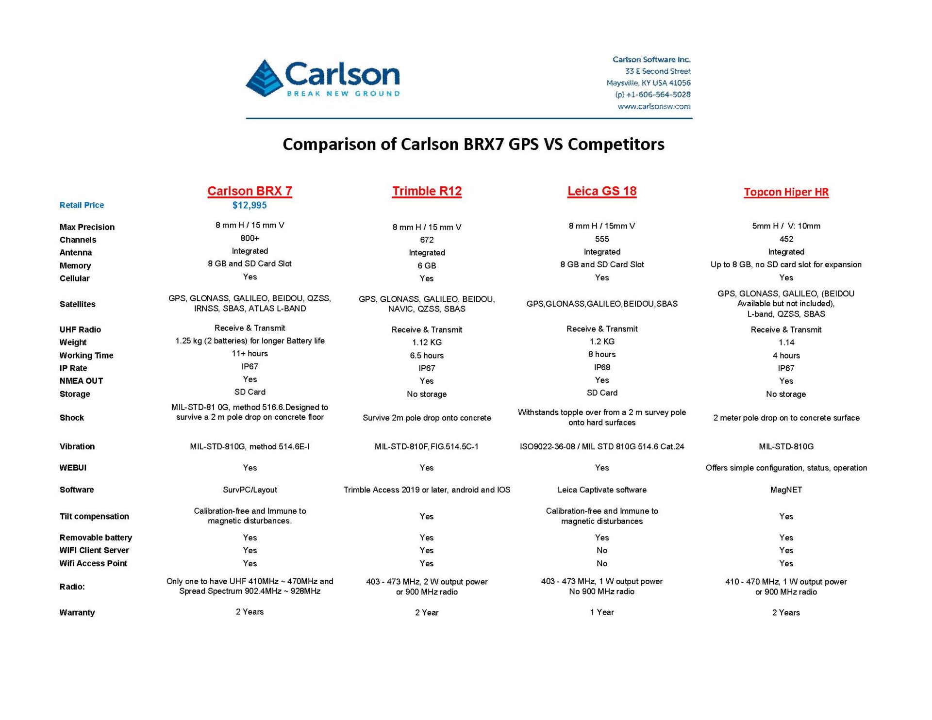
BRx7 Rover RTK GPS Receiver
Use the BRx7 as a precise network rover to work with your GNSS VRS network, or set up your BRx7 as an easy-to-use base-rover package with industry-leading performance via the internal long-range and spread-spectrum radio or cellular communication via Carlson’s Listen-Listen, a unique cloud-based low latency service that eliminates baseline length restrictions of UHF radios. With only an Internet connection, you can enjoy a simple, easy-to-use base-rover solution that can also support a single base with multiple simultaneous rover connections.
The BRx7 provides state-of-the-art RTK performance when receiving corrections from a static base station or network RTK correction system. With multiple connectivity options, the BRx7 allows for RTK corrections to be received over radio, cell modem, Wi-Fi, Bluetooth, or serial connection. The BRx7 delivers centimeter-level accuracy with virtually instantaneous initialization times and cutting-edge robustness in challenging environments.
The BRx7 also features proprietary SureFix® technology to provide high fidelity information about the quality of the RTK solution, allowing enhanced and improved RTK accuracy, availability, and precision.
The built-in web user interface (WebUI) can be used to monitor and control the receiver status and operation, as well as to upgrade the BRx7 with new firmware and activations. The BRx7 is immune from magnetic interference and is both Athena™ -enabled and Atlas®-capable (subscription required).
Receiver Type:
Multi-Frequency GPS, GLONASS, BeiDou,
Galileo, QZSS, IRNSS, and Atlas L-band
Signals Received:
GPS L1CA/L1P/L1C/L2P/L2C/L5
GLONASS G1/G2/G3, P1/P2 BeiDou B1i/B2i/B3i/B10C/B2A/B2B/ACEBOC GALILEO E1BC/E5a/E5b/E6BC/ALTBOC
QZSS L1CA/L2C/L5/L1C/LEX IRNSS L5 Atlas
Channels:
800+
RTK Formats:
RTCM2.1, RTCM2.3, RTCM3.0, RTCM3.1, RTCM3.2 including MSM, CMR, CMR+
Recording lntervals:
Selectable from 1, 2, 4, 5, 10 Hz (20 Hz or 50 Hz optional)
L-Band Receiver Specifications
Receiver Type:
Single Channel
Frequency Range:
1525 to 1560 MHz
Sensitivity:
-130 dBm
Channel Spacing:
5.0 kHz
Satellite Selection:
Manual and Automatic
Reacquisition Time:
15 seconds (typical)
- Multi-frequency GPS, GLONASS, BeiDou, Galileo, QZSS, IRNSS, and Atlas L-band
- Long-range RTK baselines up to 50 km with fast acquisition times with the use of Listen-Listen***
- UHF (400 MHz & 900 MHz), cellular, Bluetooth, and Wi-Fi wireless communication
- The BRx7 Athena GNSS engine providing best-in-class RTK performance
- Internal tilt sensor corrects collected point coordinates to within 2 cm
Receiver Type:
Multi-Frequency GPS, GLONASS, BeiDou,
Galileo, QZSS, IRNSS, and Atlas L-band
Signals Received:
GPS L1CA/L1P/L1C/L2P/L2C/L5
GLONASS G1/G2/G3, P1/P2 BeiDou B1i/B2i/B3i/B10C/B2A/B2B/ACEBOC GALILEO E1BC/E5a/E5b/E6BC/ALTBOC
QZSS L1CA/L2C/L5/L1C/LEX IRNSS L5 Atlas
Channels:
800+
RTK Formats:
RTCM2.1, RTCM2.3, RTCM3.0, RTCM3.1, RTCM3.2 including MSM, CMR, CMR+
Recording lntervals:
Selectable from 1, 2, 4, 5, 10 Hz (20 Hz or 50 Hz optional)
L-Band Receiver Specifications
Receiver Type:
Single Channel
Frequency Range:
1525 to 1560 MHz
Sensitivity:
-130 dBm
Channel Spacing:
5.0 kHz
Satellite Selection:
Manual and Automatic
Reacquisition Time:
15 seconds (typical)
PHYSICAL
Size: 5.40″W x 8.48″L x 1.36″D (137 x 215 x 35mm)
Weight: 1.5-2 pounds (680–907 g) depending on battery configuration
Lightweight and ergonomic design Durable, chemical- and shock-resistant design
Easy-to-grip, impact-absorbing, overmolded bumpers
DURABILITY: JUNIPER™ RUGGED
IP68 waterproof and dust-proof
Operating temperature: -4 F to 122 F (-20 C to 50 C)
Storage temperature: -22 F to 158 F (-30 C to 70 C)
Shockproof: multiple drops from 4′ (1.2 –1.5 m) onto concrete
Designed for MIL-STD-810G test procedures: Method 500.5 Low Pressure (Altitude); Method 501.5 High Temperature; Method 502.5 Low Temperature; Method 503.5 Temperature Shock; Method 506.5 Rain; Method 507.5 Humidity; Method 510.5 Sand and Dust; Method 512.5 Immersion; Method 514.6 Vibration; Method 516.6 Shock
DISPLAY
Active viewing area: 7″ (178 mm)
Resolution: WXGA (1280 x 800)
High-visibility backlit LCD for best-in-class sunlight view-ability
Portrait or landscape orientation with automatic screen rotation
PORTS
USB3.0x1
3.5 mm audio jack
12 VDC power input jack
Docking port connections (Pwr, USB 2.0, & HDMI)
Loud output speaker for noisy environments
Dual digital microphone input for improved clarity
Optional RS-232 9-Pin D-Sub connector with 5VDC power output
KEYBOARD AND INPUT
Adjustable LED backlit keys
Four-way directional navpad
Windows/home key
Power key
Enter key
Three user-programmable function keys
OEM configurable/customizable
CAMERAS (GEO MODELS)
720p webcam with mic
8MP rear camera with LED illumination
Juniper GeotaggingTM: embed photo with date, time, and GNSS position
WIRELESS
Long-range Bluetooth® Smart Ready wireless technology, v5.0 +EDR, Class 1.5, BLE support
Wi-Fi® 802.11 a/b/g/n/ac, 2.4 GHz and 5 GHz
4G LTE, support for GSM or Verizon Networks
GPS/GNSS (GEO MODELS)
2 to 5 meter typical accuracy
uBlox NEO-M8N GNSS receiver and integrated antenna
Integrated real-time SBAS receiver (WAAS, EGNOS, etc.)
72 GNSS tracking channels
Optional: uBlox NEO-M8T w/post-processing capability and external GNSS antenna pass- through connection for sub-meter accuracy
ACCESSORIES
Standard removable battery
AC wall charger with international plug kit
Capacitive small-tip stylus w/tether
Quick Start Guide
Hand strap
Connector port dust cover
Advantages
- Increased hardware capability
- Increased virtual memory & ability to work with large sets of data
- Larger screen size & more convenient touch screen usage
- More processing & graphic power (with aerial photo overlays)
- Save directly to an Esri geodatabase with no import/export
- File formats compatible with Carlson office products (.fld, .flc, etc.)
- Import of MicroStation .dgn files and Import/Export of AutoCAD .dwg files is possible. Output to Excel for simple data management.
Description
New from Carlson SurvPC is the ability to work in the Esri® ArcGIS® system, yet with a familiar interface, achieving seamless accuracy in GIS. New functionality allows users to use Esri’s Map Objects to perform all survey functions with no downtime learning new software. In the new ArcGIS-enabled version of Carlson SurvPC, Esri’s Desktop can be used intuitively to perform all survey functions; ArcGIS points, lines and polygons can be used for staking. ArcGIS Nodes can be used for resections and localization; and users will be able to query GIS feature attributes at any time with the Store Points, Stake Points, and Map View screens.
Minimum Hardware Recommendations:
– Intel Pentium® or more powerful processor
– 64-bit machines are supported, but application itself is 32-bit
– 256 MB RAM (minimum), 512MB or 1 GB recommended
– 256 MB of free hard disk space
– 1 x 9-pin serial RS-232 port optional
– Wireless LAN 802.11 b/g/n optional
– Integrated Bluetooth v.2.0
– Specifications Subject to Change without Advance Notice
Note: UHD (4K) Tablets are not supported at this time
Operating Systems Requirements:
Version 5.x – Supports up to Windows OS, 10. max*
Version 4.x – Supports up to Windows OS, 8.1. max*
Version 3.x – Supports up to Windows OS, 8.1. max*
Version 2.5 – Supports up to Windows OS, 7. max*
*Running on an operating system not listed with the SurvPC version above could lead to technical issues. It is recommended to contact us for upgrading options.