-

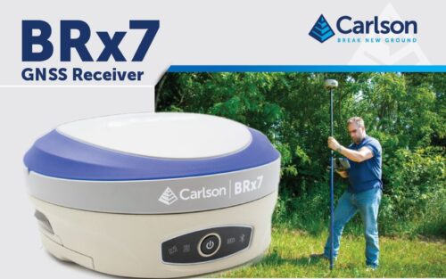
 The BRx7 is Carlson’s all-new multi-GNSS, multifrequency smart antenna. The BRx7 provides robust performance and high precision in a compact, rugged package with tilt compensation ability. With multiple wireless communication ports and an open GNSS interface, the BRx7 can be used in a variety of operating modes.
 -
Sale!
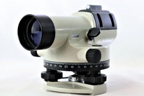
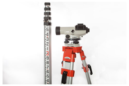
 The ALLENBUILD™ AB24 Level is an affordable, reliable & hardy instrument for all construction and surveying applications. It has a robust housing, an adjustable mirror for easy readings during leveling, and a magnetic damping compensator.
 -
Sale!Out of stock
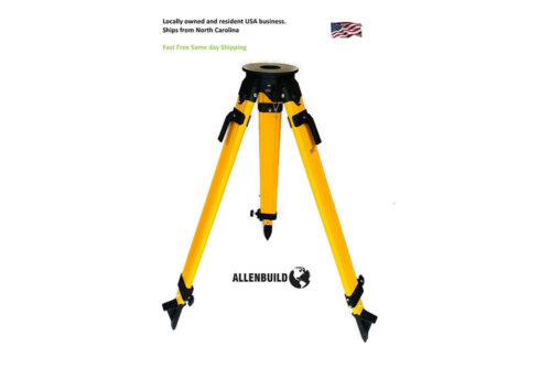
Quality Allenbuild Aluminium 5/8inch Flat Head Tripod Most popular seller. Allenbuild Aluminum Tripod with Quick Clamps is a strong tripod suitable for construction conditions. It has a carry strap and is easy to transport. Each leg has an individually machined strong tip that is suitable for hard and soft ground. Most popular seller. This light aluminum tripod is ideal for any survey application.
-
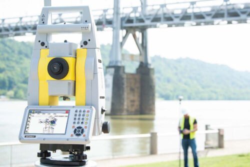
This pricing is for the CRx5. Give us a call for other version availability and pricing. With a 5” touch screen, a more powerful processor for large files, automatic data backup, and the advanced positioning technology of STReAM360, Carlson’s super-reliable CRx robotic total station provide the most efficient way to survey. • X-MOTION™ Hybrid Drives • Scout: Quickly search for passive prisms • Full Connectivity • Robust, field-proven package • accXess™ EDM Technology • 1”, 2”, 3”, and 5” options Made for Carlson SurvCE | SurvPC The CRx series robotic total stations work flawlessly with SurvCE and SurvPC data collection software and come with an integrated copy of SurvCE installed. Focused on Productivity The Carlson CRx series robotic total station is quick to set up, and are packed with easy-to-use functions that simplify your surveying workflows and provide powerful tools to make you more efficient and more accurate.
-
This package comes with:
- AB24 Autolevel
- Aluminum 5/8inch Flat Head Tripod (Our most popular seller)
- Staff rod (metric and standard readings 5m)
-
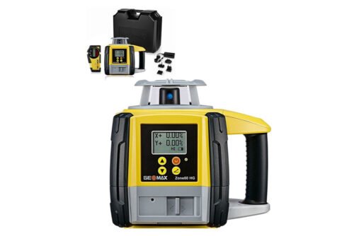
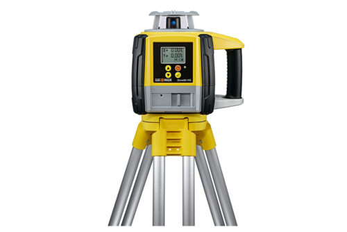
The Zone60 HG is a semi-automatic laser rotator. Semi-automatic means that the laser self-levels only when in Level mode, not when grade is entered. The Zone60 HG is a laser tool for general construction and leveling applications such as:
-
- Setting forms
- Checking grades
- Controlling depths for excavations
-
- Driveways
- Parking lots
- Landscaping
-
-
Out of stock
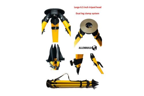
Quality Allenbuild Fiberglass 5/8inch Flat Head Tripod: Most popular seller. Allenbuild Heavy duty Fiberglass Tripod is a strong tripod suitable for construction conditions. It has a shoulder/carry-strap and is easy to transport. Each leg has an individually machined strong tip that is suitable for hard and soft ground. Most popular seller. This HD fiberglass tripod is ideal for any survey application. See demo on youtube: https://youtu.be/040Wqwg5tvE
-
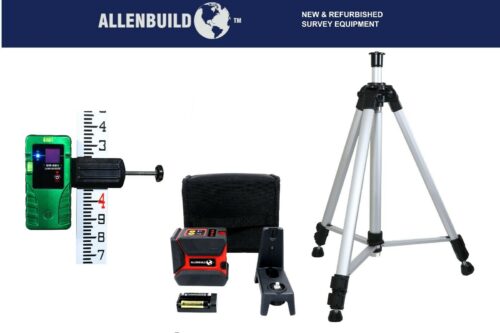
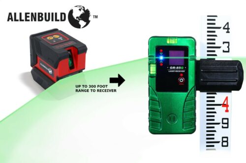
Self levelling bright GREEN line laser level for indoor and outdoor levelling. Complete kit with tripod and receiver.Comes with:
- ABSL10G Green line laser with batteries
- Soft padded carrybag
- Green Laser receiver AB85G, range with receiver 100m/300ft
- Mounting bracket for levelling rod
- 3 Penlight AA batteries
- Bracket with magnets for wall mounting and your survey tripod mounting.
- With tripod elevating to 1.9m or 5.7 feet
- With laser receiver with LED light indicators and audible beep.
-
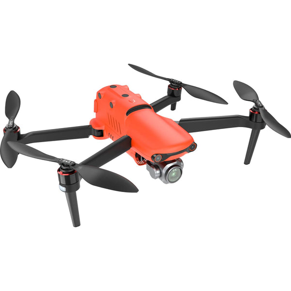
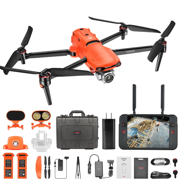
 The EVO II Pro RTK provides a proven, accurate, durable, and user-friendly, FAA Remote ID Compliant Unmanned Aircraft System (UAS) for numerous applications, including the creation of surfaces, point clouds, and orthoimages with Carlson PhotoCapture, as well as feature extraction and CAD plans with Carlson Point Cloud. This package includes PhotoCapture Standalone for Desktop and Carlson Point Cloud to take your aerial data to finished deliverables, the EVO II Pro offers up to 36 minutes of flight time, high accuracy positioning with its detachable RTK module, a 20MP camera with 1″ sensor, and built-in mission planning for simple setup in the field.
 -
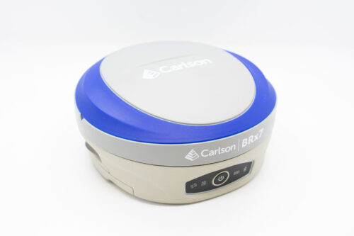
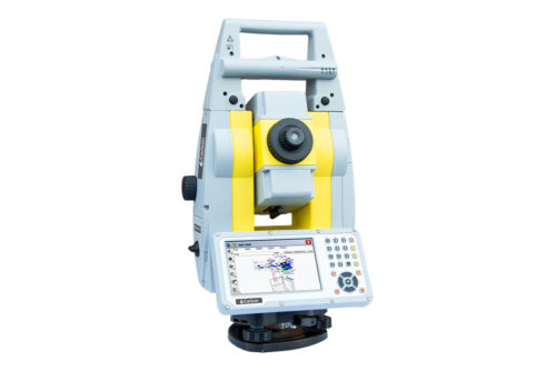
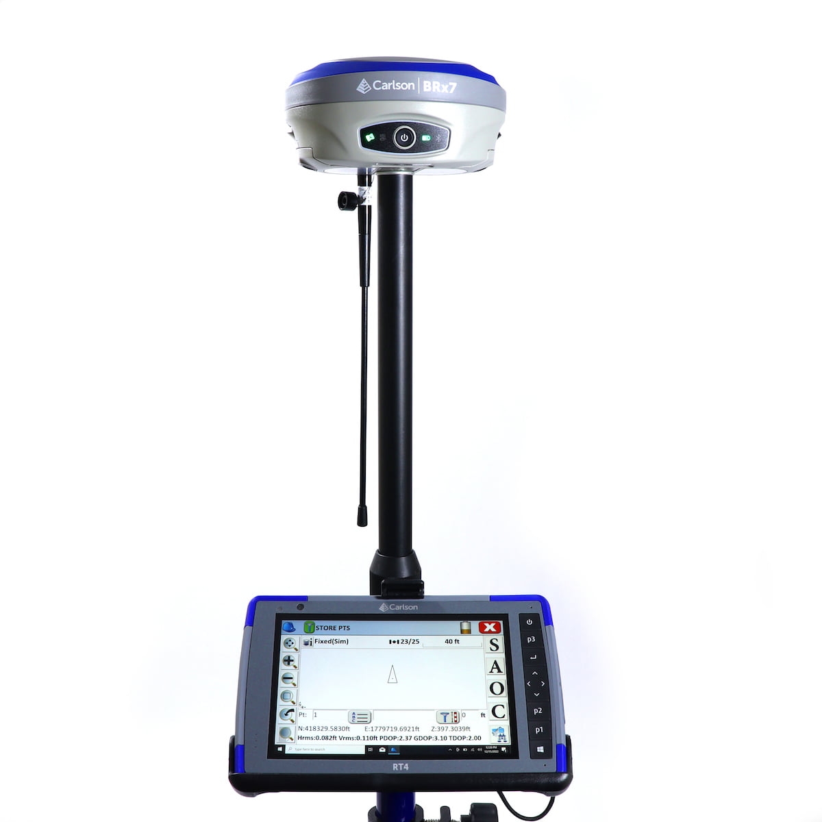
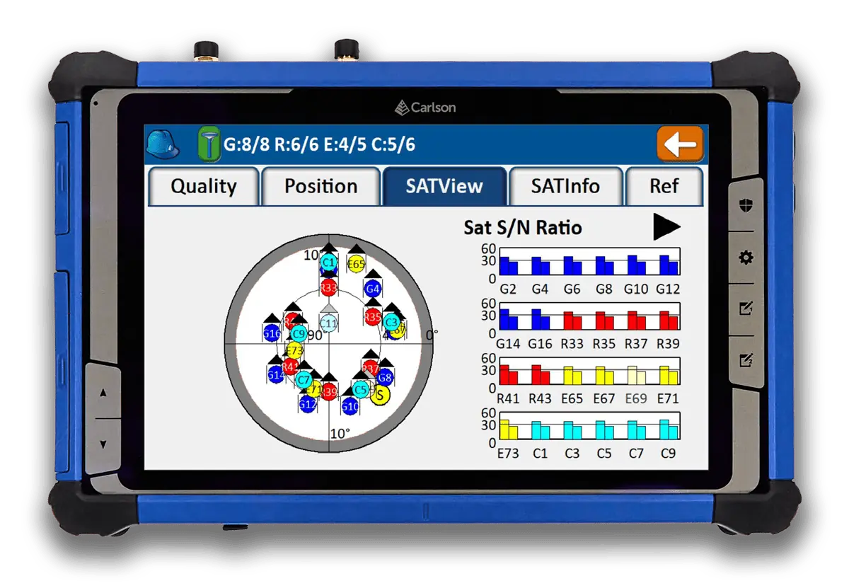
 This Carlson BRx7 Rover Package includes the Carlson BRx7 GNSS Receiver, the Carlson RT4 Tablet Data Collector, SurvPC GPS software, a survey pole, and an attachment for the tablet to the pole.
- The BRx7 rover is Carlson’s all-new multi-GNSS, multifrequency smart antenna. The BRx7 provides robust performance and high precision in a compact, rugged package with tilt compensation ability. With multiple wireless communication ports and an open GNSS interface, the BRx7 can be used in a variety of operating modes.
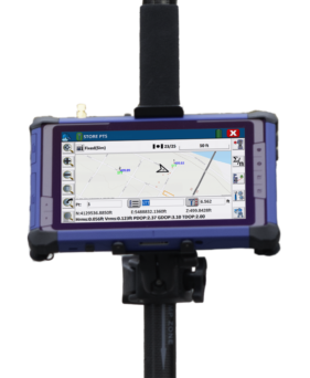
- The Carlson RT4 Tablet is designed for surveying, stake out, construction layout and GIS mapping and is bundled with Carlson SurvPC GPS with the option of running with the Esri® OEM program for use in the field. Or use in the office with any Carlson office software. Along with the 8GB of RAM and 128GB of storage, you can collect and analyze your data quicker than ever before.
- SurvPC supports the widest range of popular and new release RTK GPS and conventional/robotic total stations. Carlson SurvCE and SurvPC are complete data collections systems for Real Time Kinematic (RTK) GNSS and Total Stations with in-field coordinate geometry. SurvPC can be utilized on standard Windows PC computers such as ruggedized laptops.
-
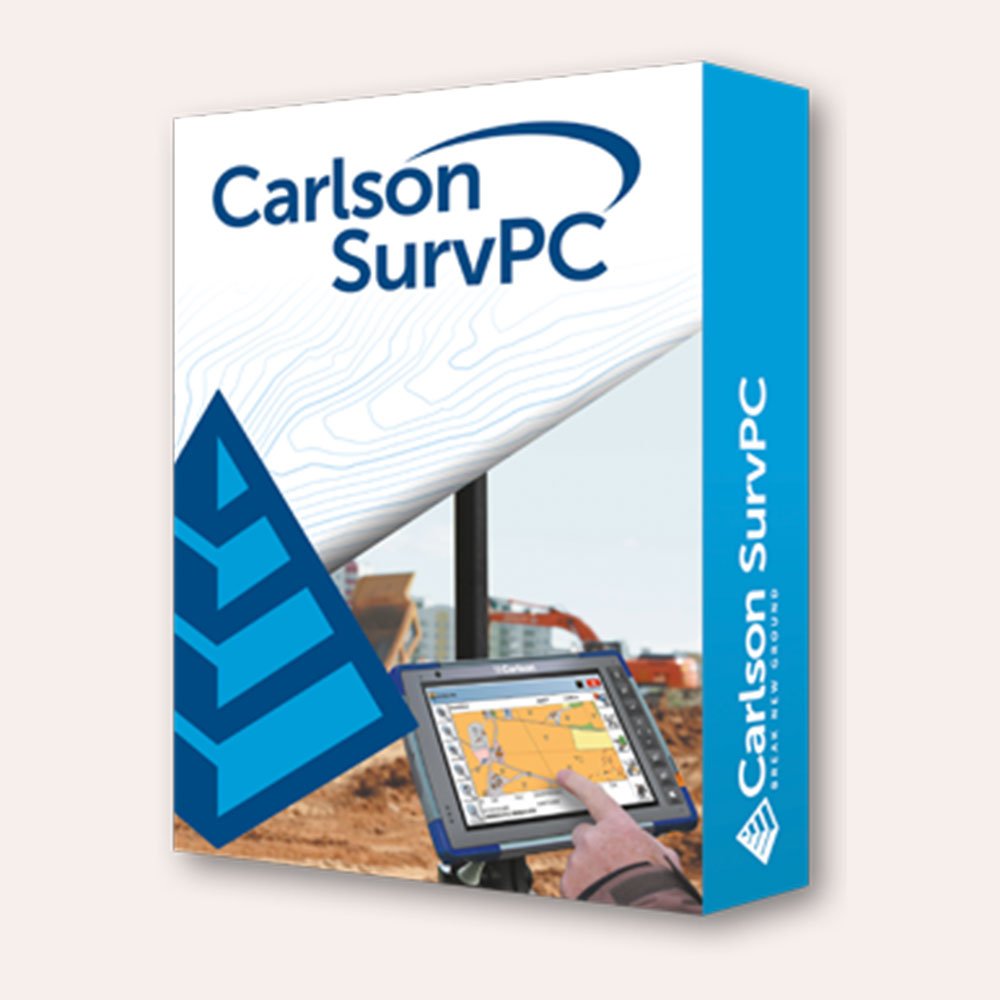
 SurvPC supports the widest range of popular and newly released RTK GPS and conventional and robotic total stations, putting the power of Carlson’s in-field coordinate geometry at your fingertips. Note that this is an upgrade from Version 6 - click here to buy SurvPC 7 instead of an upgrade. You can add own the Carlson SurvPC Robotic Module here: New features of SurvPC 7 include:
- SurvNet least squares adjustment in the field
- BIM Support for viewing and 2D/3D staking (IFC and RVT)
- Esri ArcGIS Online integration
- Enhanced graphical averaging with full data visibility
- Customizable report generation with field email option
- Catenary survey for robotic total station
- Auto refreshing reference drawings
- Total station monitoring
- Advances in road staking to support BIM and DTM models with real time sectioning
- Fully customizable user hot list
-
There’s a reason surveyors make Carlson their first choice in data collection software. SurvPC combines advanced functionality, ease-of-use, and cutting-edge features with excellent service and award-winning technical support. SurvPC supports the widest range of popular and newly released RTK GPS and conventional and robotic total stations, putting the power of Carlson’s in-field coordinate geometry at your fingertips. New features of SurvPC 7 include:
- SurvNet least squares adjustment in the field
- BIM Support for viewing and 2D/3D staking (IFC and RVT)
- Esri ArcGIS Online integration
- Enhanced graphical averaging with full data visibility
- Customizable report generation with field email option
- Catenary survey for robotic total station
- Auto refreshing reference drawings
- Total station monitoring
- Advances in road staking to support BIM and DTM models with real time sectioning
- Fully customizable user hot list
-
SurvPC supports the widest range of popular and newly released RTK GPS and conventional and robotic total stations, putting the power of Carlson’s in-field coordinate geometry at your fingertips. Note that this requires SurvPC Basic (TS). New features of SurvPC 7 include:
- SurvNet least squares adjustment in the field
- BIM Support for viewing and 2D/3D staking (IFC and RVT)
- Esri ArcGIS Online integration
- Enhanced graphical averaging with full data visibility
- Customizable report generation with field email option
- Catenary survey for robotic total station
- Auto refreshing reference drawings
- Total station monitoring
- Advances in road staking to support BIM and DTM models with real time sectioning
- Fully customizable user hot list
-

 Introducing the Carlson RTk5: Empowering Precision and Flexibility in GNSS Technology Experience unparalleled freedom and precision with the Carlson RTk5, a cutting-edge GNSS solution seamlessly integrated into the RT5. Packed into a compact, lightweight, and versatile package, this advanced device revolutionizes your surveying, engineering, GIS, and GNSS positioning needs. The Carlson RTk5 comes equipped with a range of essential features and accessories designed to enhance your productivity. Its custom-built pole and cradle provide stability and convenience, ensuring seamless operation in any environment. With the inclusion of a survey-grade antenna, you can achieve superior accuracy for your land surveying projects. For on-the-go applications, we have included a small, portable helix antenna specifically tailored for handheld GNSS use. This empowers field professionals with the flexibility to capture precise positioning data on the move. GNSS CAPABILITIES • Advanced multi-frequency, multi-constellation (GPS + GLONASS + Galileo + BeiDou + QZSS) RTK GNSS performance • Balanced & ergonomic; 25+% lighter than typical GNSS setups – 6 lbs (2.7 kg) with tablet, cradle, pole, and antenna • Gather live, centimeter-level positions directly into an Esri database with zero post processing • Operate handheld without a pole for fast GIS work
 -

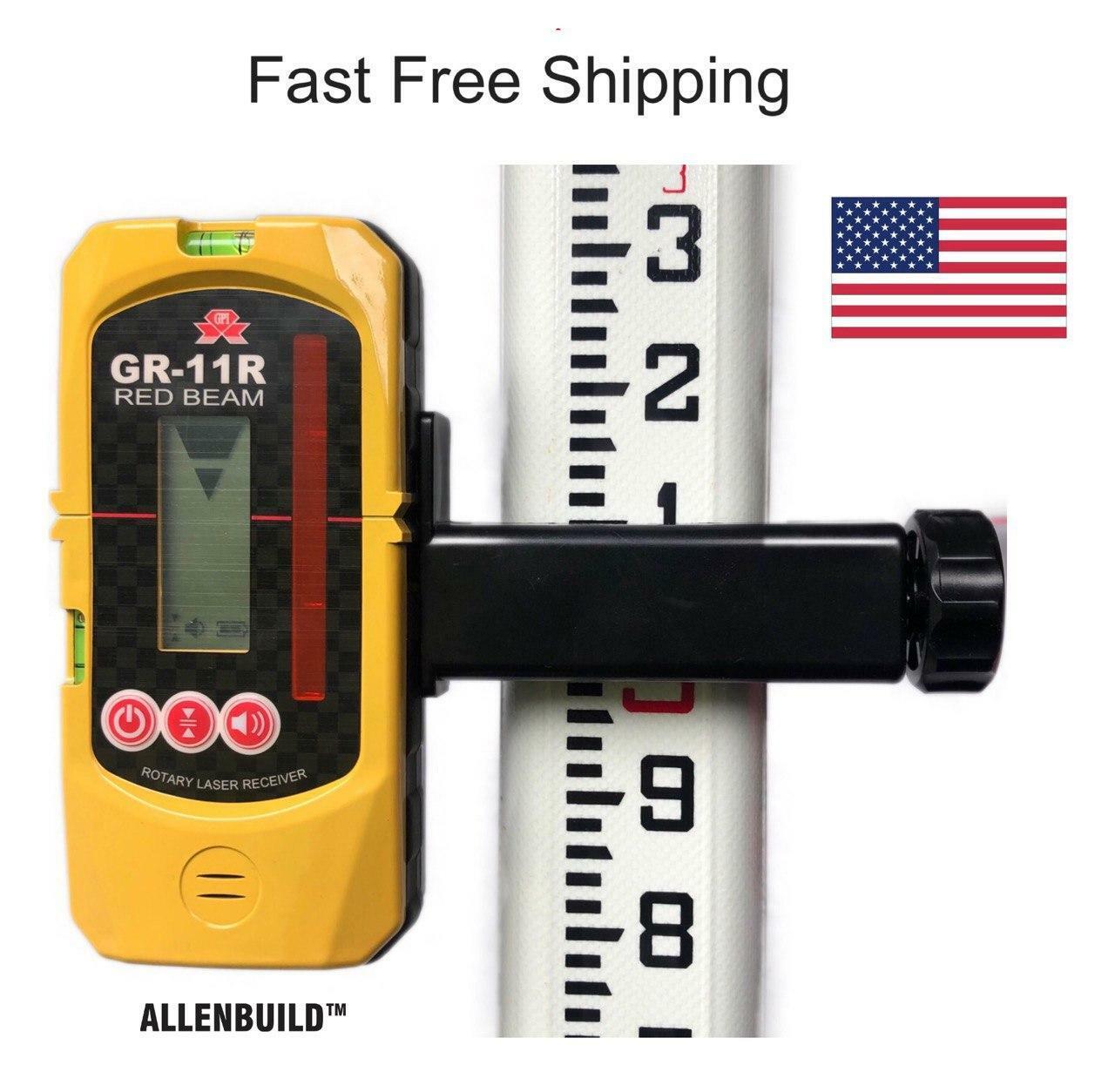
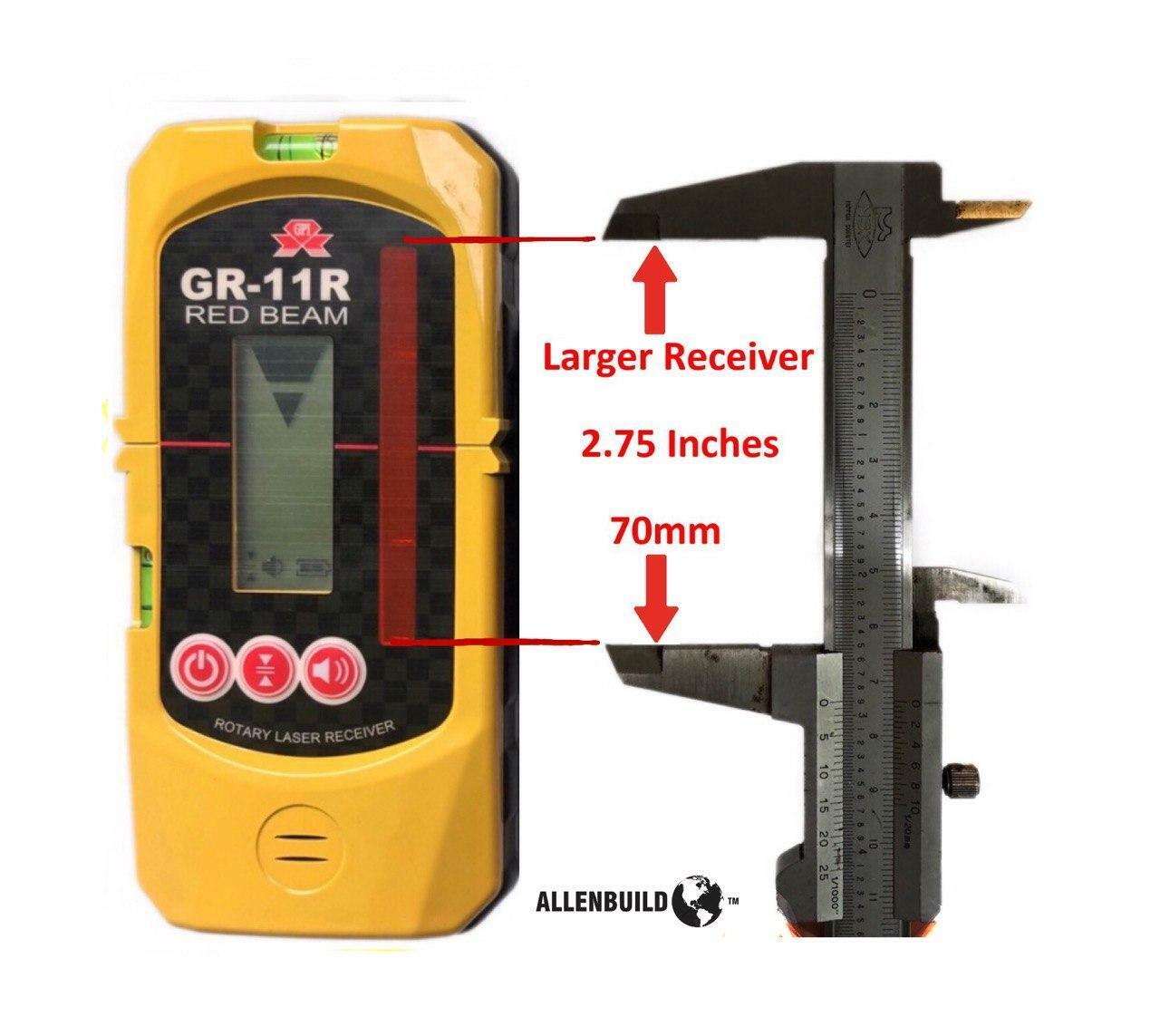
 Free Shipping The Allenbuild Red Laser receiver AB11R is an all-purpose, universal rotary laser receiver with a protective rubber bumper. It is used for detecting the red laser beams in indoor or outdoor conditions where it cannot be seen by the naked eye, such as large construction sites, or for home DIY use. It comes with a rugged bracket, which opens to fit most aluminum and fiberglass staffs and rods up to 65mm/2.1inch wide. The bracket is removable, and the unit can be used to mark out reference points on walls with a pencil in the grooves provided. It operates on two standard AA penlight batteries, and it automatically switches off to save power when not in use.Note: This receiver has bigger range than general small receivers, this laser receiving window range is 70mm (2 3/4 inches) up and down, compared to +- 40mm/1.5inch on other smaller receivers.Very easy to use, complete with leveling rod bracket and 2 bubbles built into receiver, to level it. Fine and rough settings.The device fits all standard leveling rods and is compatible with all laser brands including Topcon, PLS, Spectra, Bosch, Johnson, Acculine, Hilti, CST/Berger, Leica, and Dewalt.Watch a YouTube demo: https://youtu.be/BwiIAnw8H3s
 -

 End of year special: CRx 5" plus RT5 Tablet w/ SurvPC Total Station & RTS The Carlson CRx series of Robotic Total Stations provides a choice of 1″, 2″ and 5″ angular resolutions to match the application requirements. This offer is for the 5". This model is the CRx-5 for a seamless user experience. The instruments are combined with SurvCE or SurvPC on a field computer to access the full range of Carlson survey features for efficiency and automation in a familiar environment. In addition, users have the option for installing SurvCE Basic on board for operation with the instrument only. Customers benefit from technical guidance and support for both the robotic total station and SurvCE or SurvPC from one company. CRx Robotic Total Stations are used with SurvCE or SurvPC in a wide range of applications requiring precise angle and distance measurements such as surveying, engineering and construction.
 -
End of year special: CRx 2" with RT5 Tablet plus SurvPC Total Station & RTS The Carlson CRx series of Robotic Total Stations provides a choice of 1″, 2″ and 5″ angular resolutions to match the application requirements. This offer is for the 2". This model is the CRx-5 for a seamless user experience. The instruments are combined with SurvCE or SurvPC on a field computer to access the full range of Carlson survey features for efficiency and automation in a familiar environment. In addition, users have the option for installing SurvCE Basic on board for operation with the instrument only. Customers benefit from technical guidance and support for both the robotic total station and SurvCE or SurvPC from one company. CRx Robotic Total Stations are used with SurvCE or SurvPC in a wide range of applications requiring precise angle and distance measurements such as surveying, engineering and construction.
ShopSally Compton2023-02-21T03:43:31+00:00